Back to Tour Information
Vehicle, Koni & Communications
Site Map
During our tours Connie will always show folks where Len’s roads are, most of which are marked by the famous aluminium stamped plaques that Len put up during the road construction as there were no road signs and in most cases there still isn’t. What most people don’t realise is that in some cases what is shown on maps today has little to do with the original placement & length of some of the first desert roads. This is just a little article with a few maps & photos to show those that are interested that sometimes they are not on the roads they thought they were on if you take history into account.
These are the roads we’ll have a look at;
The problem with the Gunbarrel is that modern maps and state naming boards have cut it up into bits which make it difficult to work out the original line of the road that Len & the boys cut in the 1950s. I won’t bother going into the history of why the roads were made, you can do that. You’ll often see articles about Gunbarrel Expeditions done by so and so. When we look at the route they have taken we have a little chuckle. Often as not they have only covered less than half of the road's length and rarely mention anything about why they didn’t do the whole lot.
I’ll run through the different sections of the road and where they still are in most cases. Hema maps make the best background for this as they include the little bits of information on the maps that Connie wrote for them many years ago when Hema’s Desert Tracks Maps were first published.

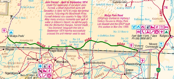
| Victory Downs to Mulga Park – no permits required. |
The very first section of the road later called the Gunbarrel Highway. These days it is called the Mulga Park Road as you can see. You don’t need aboriginal permits for this bit so some folks use it as a dirt road alternative to go to & from Curtin Springs and Ayers Rock.
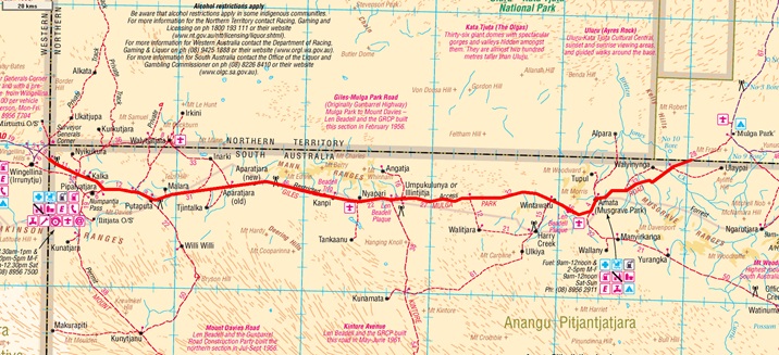
| Gunbarrel Highway within South Australia – No transit permits are being issued. |
The above Gunbarrel route through South Australia has always been a problem since that area was handed back freehold to the Anangu Pitjantjatjara decades ago. Transit permits were not issued to travellers unless you had business in those APY Lands for example, Telstra and tradies etc. Beadell Tours were given permits for many years as we had plaque maintenance to do plus a few other reasons. In the last few years permits have tightened up even more and we can longer enter APY Lands in South Australia. This makes that section of the Gunbarrel out of bounds.
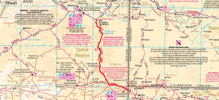
| Gunbarrel Highway – SA Border to near Giles/Warakurna – permits required. |
For the above north south section permits are required from Ngaanyatjarra Council but normally are not that difficult to obtain and they are free. This bit of road is the bit folks use to see Surveyor Generals Corner near Wingellina community.
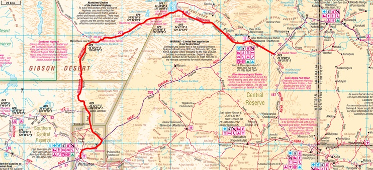
| Gunbarrel Highway between Giles & Warburton – permits required. |
The above part of the Gunbarrel is/was called the "abandoned section" because not that many years ago permits were not issued for this road at all, after 1996 the Ngaanyatjarra Council relaxed a little and permits began to be issued with some special conditions such as you couldn’t travel on your own plus a few other things. These days permission is quite possible and permits are free. Frequent desert travellers normally call it the "old Gunbarrel" these days.
From Jackie Junction to Warburton was a part of the original network, if you were thinking that seems a little odd. It was figured that Warburton Mission could use a road link to the east. At that time the only made road to Warburton was the track to Laverton which had only been graded a few years before in about 1952. (It’s part of the Central Road these days.)
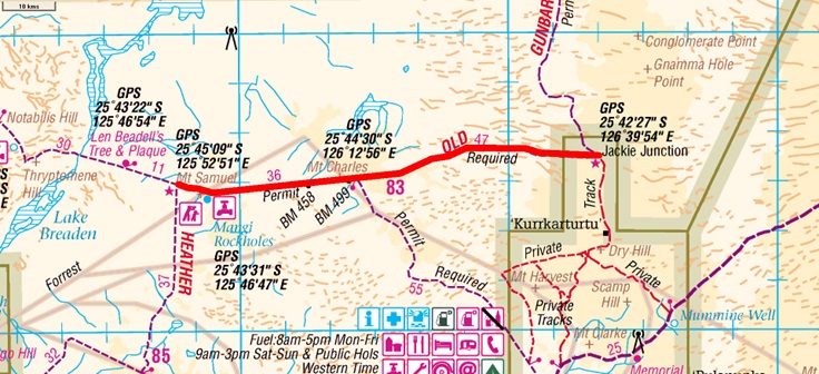
| Gunbarrel Highway – Jackie Junction to Heather Highway Junction – permits required. |
The section running west from Jackie Junction is still listed as needing special permission. If you want to travel this road then it is best to contact Warburton and get a permit directly from the community. The normally issued permit will direct you to use the Heather Highway to join the Central Road.
** A point of interest here as most people don’t know how the Heather Highway got its name. Without going into the whole story in detail, the name Heather comes from the infant daughter of the Warburton Superintendent back in the early 1970s. Surveyors named the road at the time while they were working in the area. **
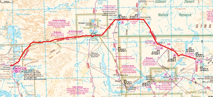
| Gunbarrel Highway – Heather Highway to Carnegie Station – permit required (eastern bit). |
Not much to explain here at all. This is the bit that everybody does and knows about. A permit is required for the eastern part of this section but apart from that it is permit free a bit north west of Mt Beadell as things stand at the moment.
It had a fierce reputation for corrugations that was well earned. These days you can still get a rattle out of it but nothing like 20 odd years ago. In fact there are just as many wash-outs along that section now as corrugations. Travelling most of that road now is even slower just due to the weather damage over many years. Don’t take that as meaning the Gunbarrel won’t damage your vehicle because if anything is going to fall off your bus the Gunbarrel is still quite capable of making your trip a nightmare if you aren’t well prepared.
**Another point of interest is that the road from Carnegie Station to Wiluna is NOT the Gunbarrel Highway and has never been so. Len & the boys cut the road to Carnegie and then the gear was parked up, road completed. In 1958 there was no major road as there is now that went direct to Wiluna from Carnegie Station, only a network of station tracks. Over the years since 1958 these station tracks became the big road that is there now, nothing to do with the Gunbarrel Road Construction Party.**
Most of the Sandy Blight Road is correct, the only bit that is of interest for this article is the most southern bit of the road, what we call the "Start of the Sandy Blight". In 1960 the Central Road didn’t exist, there was no direct road link between Warburton Mission and Ayers Rock, those roads didn’t come about until the late 1970s. The only made roads were what Len and the boys of the Gunbarrel Road Construction Party were making. In 1960 there was only the Gunbarrel Highway in that area, nothing else but the odd set of wheel tracks here & there. It would pay to remember that the only Aboriginal Missions in the deserts were Warburton & Ernabella. All the other communities did not exist, however there were a few ration depots for the nomadic aboriginal people still around at that time. Quite some years later some of these depots became the communities that we know today. The best way to illustrate the real Sandy Blight compared to what is known today is show a section of an old map compared to a modern map. So here it is.
I forgot to mention you need permits to travel the length of the Sandy Blight, two in fact as the road runs through both Western Australia and the Northern Territory. Both are free.
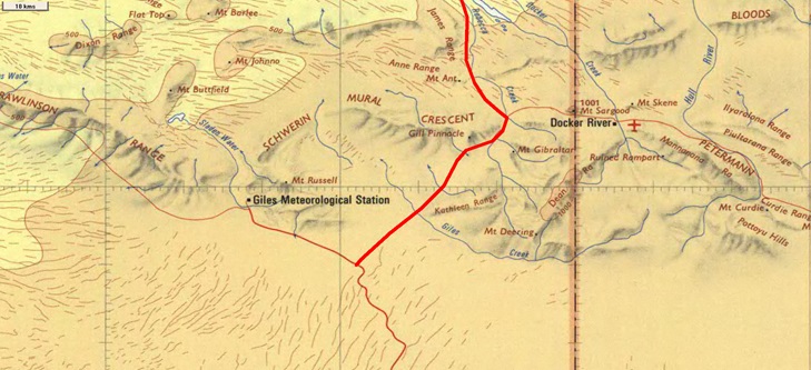
| This map is from the mid-1970s as Docker River is depicted and it got started as a community in something like 1970. As the red route shows, the Sandy Blight starts quite close to Giles Weather Station. You’ll note there is no road going south-west to Warburton at all. |
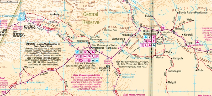
| This is a modern map zoomed to about the same size. You can see the obvious differences with everything! The Central Road has taken precedence and is more clearly defined than the Sandy Blight so with the overlay of the same route people now assume that the Sandy Blight Junction Road starts from the Central Road at Rebecca Creek some 77 kms from Giles/Warakurna Roadhouse. It’s an easy assumption to make.
Below is a picture of the plaque positioned at the head of the Sandy Blight Junction Road and an exact replica of the original placed by the fellow that made the roads, namely Len Beadell. You’d have to think Len knew where his own roads were! |
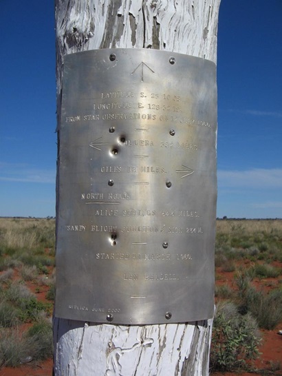
| From the actual start of the Sandy Blight, Giles is only 18 miles away (29 kms). |
On the modern version of the Central Road this plaque and the T junction with the Gunbarrel have been bypassed. The new alignment is a big smooth curve to the north of the old road junction so very few people even know that the old roads exist anymore. That is how history is. Small details are forgotten as time moves by. If you are an avid Beadell Tracks fan this might give you an extra buzz as you travel the roads in the future if you didn’t already know.
There are very people on the planet currently that know anything about this road, the second last road made by the Gunbarrel Road Construction Party. There are a couple of problems with this Beadell track, the first being that the area is under native title these days and permission to travel the "road" wasn’t likely to be approved last time Connie & I checked. The second problem is that it is no longer a road or even a track. Len’s road from Gary Junction to the north-west was never used a great deal and so has returned to the desert and only in a very few places can you see where the original grader scrape has been. We are including it here for the sake of accuracy as most travellers assume a nearby road is Len’s road, it is not.
The other road in the same area is the Kidson Track/WAPET Road (West Australian Petroleum – WAPET called their own road the Kidson Track) which runs from Eighty Mile Beach inland to the south-east until it joins the Gary Highway south of Gary Junction. For interests sake both roads were put in about the same time but the Kidson Track was a much bigger affair as drilling rigs and heavy gear had to be taken into the desert to search for oil. Whereas Len’s road was a grader scrape largely through sandhill country. As time went by the bigger, much better built, road was used by travellers and Len’s road went back to nature, forgotten.
The following map should make it a bit clearer where the two roads are and yes at times they do coincide but for only small distances. Both roads are more than 600 kms long.
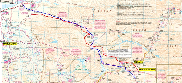
| Len Beadell’s Callawa Track in red
WAPET’s Kidson Track in blue |
If you want to read about the Callawa Track then Len Beadell’s book "End of an Era" covers the making of the Gary Highway, Windy Corner Road and the now lost Callawa Track. This all happened in 1963 and were the last roads built during the eight year road construction project.
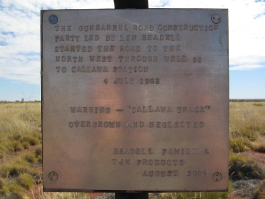
| This is a plaque that was put up near Gary Junction by our party in 2004, essentially warning travellers not to travel the Callawa Track. (By the end of that trip in 2004 following Len’s road we had a total of 72 flat tyres amongst 8 vehicles and fuel consumptions as high as 45 lts/100 kms all in 18 days.) |
Since the early 2000s the Native Title claims that have been granted in the western deserts over Crown Land number quite a few. Without delving into how all of that works it is easier just to say many of the High Court decisions give exclusive use to many roads to the claimants. This means legally the roads can be closed completely or put under a permit system or even a toll if the owners wish it.
So, which roads and tracks are now closed off or a permit needed? I’ll just deal with the closed roads as obviously if they are not closed that means you can get permission even if it is difficult. I’ll do a brief description and a small map.
Callawa Track - closed - as detailed above
Gunbarrel Highway - (South Australian section) - no permits being issued - detailed above
Eagle Highway - closed - Put in by the Eagle Oil Company in the 1980s. Originally it ran from the Central Road up to near Windy Corner but in 1996 the bottom half from the Gunbarrel down was renamed "The David Carnegie Road" for the centenary of David Carnegie’s remarkable double crossing of the deserts in 1896/97.
Around 2010 the area between the Gunbarrel & the Windy Corner Road was determined and the road was then closed to all traffic. We haven’t been up there for quite some years now but the last time in 2013 we had permission and the road had overgrown to the point that I spent quite some time cutting scrub and limbs from the roadside.
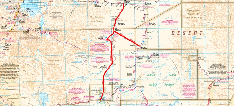
| Eagle Highway – closed to travellers unless given special permission last we heard. |
This made by Len and the boys and was a short-cut between the Gunbarrel and the Mt Davies Road. The Waturu community has closed near the southern end of this track so it doesn’t get much traffic these days.
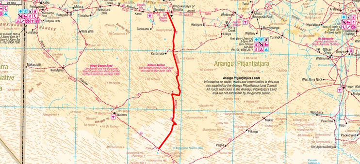
| Kintore Avenue - closed. |
This is one of Len’s roads put in during the hey-day of the Woomera rocket programs & Maralinga Atomic testing in the late 1950s. It runs from the Anne Beadell Highway north-west up to Mt Davies on the Gunbarrel. These days there is a community there called Pipalyatjara.
This road was always a tough one because it crosses a huge patch of sandhill country and things haven’t changed at all. One of Len's plaques had a warning about having to cross "190 sandhills in 70 miles".
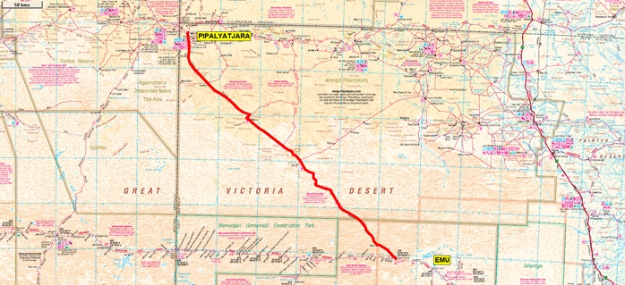
| Mt Davies Road. |
This was the first road cut in 1955 by the team Len put together for his road gang. They became famous later on as the Gunbarrel Road Construction Party. The road joins Maralinga & Emu and was made so gear & equipment could be brought down from the Emu village and test sites to the new facilities being set up for the Maralinga atomic testing.
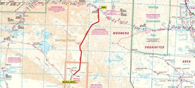
| Emu to Maralinga Road - closed. |
That should give anyone who is interested a bit more information about the western desert road network. There are plenty of other smaller roads and detours that are officially closed but an article covering all of them would be huge. However as an example if you are travelling the Connie Sue Highway with a standard online permit and wish to go into Waterfall Gorge for instance that permit doesn’t allow for you to do that detour or any other for that matter. You need special permission from the Warburton community to detour from the Connie Sue Hwy. Read your permit information.
As to getting permits that is a subject for another article. The one thing we have noticed over the last ten years as the automatic online permit system has been developed (which is really very good) is that many travellers do an online permit and think they can travel where ever they want. This is not the case if they bothered to read the fine print. Any online permit will only allow travel along a road, and not even all of them. They do not allow you to deviate from the road more than the prescribed 30-50 metres or whatever it is. Please fully read all of the information and look over the permit page maps. As attitudes change it is most likely there is going to be some ructions with "incorrect" permits in the future, this will impact everyone else who are trying to do the right thing. It’s an age old story. We’ll just leave it at that.
Safe travels
Mick Hutton
Copyright: June 2021
BEADELL TOURS
Mobile : 0408 841 447
Email : Beadell Tours
ABN : 40 947 959 130